EQUIPMENT
Gateway: GW3010
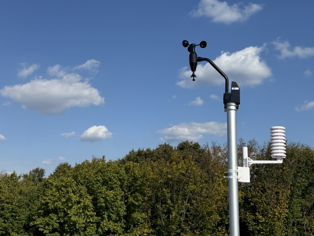
Wind: WS68
Rain (tipping bucket): WH40H
Air temperature and humidity: WN31
Lightning detector: WH57
Soil temperature: WN34
Wind: WS68
Rain (tipping bucket): WH40H
Air temperature and humidity: WN31
Lightning detector: WH57
Soil temperature: WN34
NETWORKS
Visitors:

ABOUT
Hi! I watch the weather in the Petil stream valley. Here are the readings from my yard, experiments and notes on the local microclimate.
About the station »
About the station »
« Back · Generated 17.11.2026 00:11 · methodology 2026.10-v3 · preliminary
November 2026
01.11.2026 – 17.11.2026 · 16 of 16 days
Summary
- Preliminary report: the period is not over yet.
- Mean air temperature at 2 m was +4.2 °C (time-weighted over 16 days).
- Lowest recorded temperature -2.8 °C (16.11 03:18), highest +11.2 °C (13.11 18:32).
- Days with 2 m temperature below 0 °C: 5; 35 frost hours in total.
- First 2 m temperature below 0 °C on 05.11.
- Recorded 21.3 mm of rain over 4 wet days (≥ 1 mm).
- Largest daily total 13.3 mm (11.11), largest hourly 3.5 mm.
- Longest dry spell (< 1 mm/day): 5 days.
- Maximum gust at the installation point 12.2 m/s (06.11 14:39); mean speed 1.2 m/s, calm 27 % of the time.
- 1 episode(s) of rapid pressure fall; strongest -4.1 hPa in 3 h (11.11 04:20).
- 74 hours with RH ≥ 95 %.
- Mean soil temperature at −10 cm +8.1 °C.
- Steady soil transition below +10 °C on 04.11 (first of 5 consecutive days).
- Over 380 common synoptic hours the station was on average 0.4 °C colder than Kyiv (33345); at night the difference was -0.6 °C (143 hours).
- Forecast vs fact (frozen at 18:00; 16 days common to all models): the smallest error was ICON-EU — MAE 0.72 °C, night-minimum bias +0.4 °C.
Completeness and limitations

| T | RH | P | U | R | G | Ts | Days with valid mean | gap in the night minimum |
|---|---|---|---|---|---|---|---|---|
| 100 % | 100 % | 100 % | 100 % | 100 % | 100 % | 100 % | 16 / 16 | 0 |
Air temperature (2 m)

| Mean (time-weighted) | +4.2 °C | Mean daily max / min | +6.8 / +1.7 °C |
| Abs. max | +11.2 °C 13.11 18:32 | Abs. min | -2.8 °C 16.11 03:18 |
| Warmest night (max TN) | +6.7 °C 02.11 | Coldest day (min TX) | +3.9 °C 08.11 |
| DTR (mean / max) | 5.1 / 9.0 °C | Frost hours / cold sum | 35 h / 58 °C·h |
| Days: frost (TN<0) / ice (TX<0) | 5 / 0 | Days: summer (TX>25) / hot (TX≥30) / tropical nights (TN>20) | 0 / 0 / 0 |
| HDD18 / GDD10 | 221 / 0 °C·d | First / last T<0 at 2 m | 05.11 / 16.11 |

Precipitation

| Total | 21.3 mm | Days with rain / wet (≥1 mm) / ≥10 / ≥20 | 9 / 4 / 1 / 0 |
| Rx1day | 13.3 mm 11.11 | Rx5day | 18.6 mm 11.11–15.11 |
| Max 1 h / 24 h (rolling) | 3.5 / 13.3 mm | CDD / CWD | 5 / 3 days |
| SDII | 5.0 mm/wet day | Unknown days | 0 |
Largest rain events: 11.11 01:38 — 13.3 mm in 10.7 h, I10 4.9 mm/h; 12.11 14:46 — 3.1 mm in 6.2 h, I10 2.3 mm/h; 05.11 23:09 — 2.0 mm in 12.5 h, I10 5.3 mm/h; 13.11 06:02 — 2.0 mm in 14.6 h, I10 1.2 mm/h; 02.11 07:26 — 0.4 mm in 5.8 h, I10 0.6 mm/h
Totals are increments of the WH40H cumulative counter; unknown intervals are not replaced by zero. The gauge is unheated: winter totals may not reflect real precipitation.
Wind at the installation point


| Mean speed | 1.2 m/s | Max gust | 12.2 m/s 06.11 14:39 |
| Wind run | 1703 km | Calm (<0.5 m/s) | 27 % |
| Prevailing direction (vector) | NW | Western sector share | 35 % |
The western sector is in a wind shadow. Direction at U < 0.5 m/s is ignored. Gusts are per-minute packet maxima, not the standard 3-second gust.
Pressure
| Mean (MSL) | 1019.9 hPa | Min / max | 991.6 13.11 15:37 / 1029.9 09.11 11:05 hPa |
| Fastest 3 h fall / rise | -4.2 11.11 04:54 / +7.0 13.11 21:16 hPa | Rapid-fall episodes (≤ −4 hPa/3 h) | 1 |
Solar radiation estimate (WS68) and UV
| Period total | 42 MJ/m² | Daily mean | 2.6 MJ/m² |
| Sunniest / dullest day | 5.8 15.11 / 0.7 13.11 | Max G / UV index | 548 W/m² / 5 |
Estimate from the unverified WS68 pyranometer; 'sunshine hours' are not computed (the standard criterion applies to direct radiation).
Humidity
| RH mean / min / max | 85 / 49 / 99 % | Hours RH ≥ 95 % / nights ≥ 3 h | 74 / 7 |
| Dew point min / max | -5.6 / +10.9 °C | VPD mean | 0.12 kPa |
Soil (−10 cm)

| Mean / min / max | +8.1 / +5.4 / +10.9 °C | Daily amplitude / As÷AT | 0.6 °C / 0.12 |
| Days Ts > 5 / > 10 °C | 16 / 3 | Hours Ts < 0 | 0 |
| Steady transitions | 10 °C ↓ 04.11 | ||
Comparison with Kyiv (33345)
| Common hours | ΔT mean | median | night (n) | day (n) | independent nights |
|---|---|---|---|---|---|
| 380 | -0.4 °C | -0.2 °C | -0.6 (143) | +0.0 (141) | 16 |
Kyiv SYNOP is a simultaneous external reference, not a climate normal. The difference includes the urban effect, terrain, exposure, forest influence and instrument errors; it must not be called a 'forest-edge effect'.
Forecast verification
| Model | days | MAE | bias | RMSE | |e|>2 | Tмін bias | Tмін MAE | Δtmin |
|---|---|---|---|---|---|---|---|---|
| ICON-EU | 16 | 0.72 | -0.08 | 0.96 | 5 % | +0.37 | 1.06 | 1.7 h |
| ECMWF IFS | 17 (16) | 0.73 | +0.34 | 0.99 | 7 % | +0.52 | 1.06 | 1.4 h |
| ECMWF AIFS | 17 (16) | 0.74 | -0.18 | 1.01 | 8 % | +0.52 | 0.99 | 2.0 h |
| GFS | 17 (16) | 0.93 | +0.24 | 1.22 | 12 % | +0.25 | 1.18 | 2.0 h |
| Persistence (yesterday, same hour) | 17 | 1.87 | +0.49 | |||||
By lead time (MAE, °C)
| Model | 6 h | 12 h | 24 h | 48 h |
|---|---|---|---|---|
| ECMWF AIFS | 0.70 (75) | 0.73 (74) | 0.74 (72) | 0.73 (68) |
| ECMWF IFS | 0.75 (75) | 0.83 (74) | 0.85 (72) | 0.82 (68) |
| GFS | 0.91 (75) | 0.92 (74) | 0.97 (72) | 1.08 (68) |
| ICON-EU | 0.66 (149) | 0.68 (147) | 0.74 (143) | 0.85 (67) |


Operational mode: every day at 18:00 the latest available run of each model is frozen and the following night (20:00–08:00) and day are scored. Models are scored on different numbers of days; the figure in brackets is the number of days common to all models — models can only be compared with each other on those. 'Persistence' is the baseline: the temperature at the same hour of the previous day, using only data known at 18:00 (for hours after 18:00, the day before yesterday).
Data download
daily.csv (all daily aggregates) · 2026-11.json (this report's figures)
Best viewed 800×600UNDER CONSTRUCTIONPowered by SQLite + Python
© 2026 Petil PWS · Data provided as is, no warranty · Contact the owner:
[email protected]